|
As we all keep our eyes on the potential tropical activity in the Gulf of Mexico, a common meteorological term that has been used is, “Central American Gyre”, also known as a “CAG”. What is it exactly? A CAG is a broad, closed area of circulation centered over Central America and can be difficult to forecast. These circulations usually only occur 1-2 times per year during the rainy season (May-November). They are most common in May-June and September-November. They are not so common in July-August due to evolution of seasonal flow (anomalous low level easterlies are more prevalent than westerlies due to an extension of the Caribbean low-level jet). What risk do they carry? CAGs are known to bring significant rain/flooding to Central America, as well as being a focal point for tropical cyclogenesis (Hurricane Michael (2018) originated from a CAG). On average, they carry a lifespan of a little over three days. How do they form? CAGs are preceded by anomalous low level westerly flow in East Pacific which appears to be the main contributor to CAG formation. There are several possibilities as to why these westerly winds pave way for CAG development but simply put, these westerly winds in the eastern Pacific interact with easterly winds from the Caribbean developing cyclonic curvature vorticity. As these winds converge/interact, deep convection can result, leading to latent heat release. This latent heat release redistributes the potential vorticity (PV) below itself which enhances cyclonic circulation. Another possible contributor in CAG formation is the high terrain of Central America. Within the higher terrain lie gaps, where winds funnel through and interact with each other, resulting in low-level vorticity. The anomalous low-level westerly winds that are favorable for CAG development generally occur when the MJO is in phases 1,2 & 8. Once a CAG forms, they characteristically have "lobes" of vorticity that circumnavigate about the broad circulation. Some of these "lobes" can develop into tropical disturbances when in the right environment and break away from the gyre. CAG Classifications There are two types of CAGs to become familiar with: Non-baroclinic
Baroclinic
Forecasting CAGs To be officially classified as a CAG, certain requirements need to be met. Here is a link that describes these requirements. To forecast CAGs, click here. Below is a screenshot depicting what a CAG is and the necessary requirements using the graphics from the website provided (Image credit: Papin) 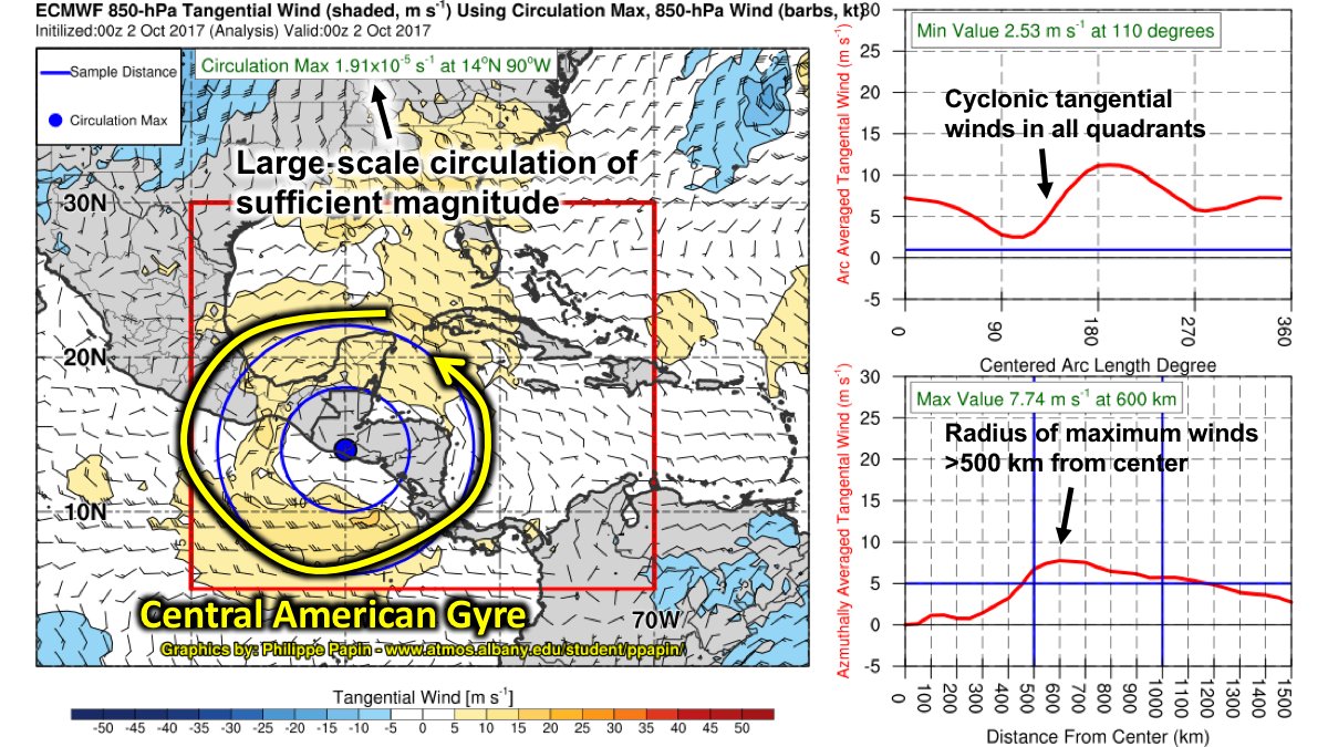 Source: Papin et.al 2017
0 Comments
Leave a Reply. |
