|
With spring now underway, that means warming temperatures. With warming temperatures underway, that means sea breeze season. Not quite how you thought that sentence would end, but as a matter of fact, without sea breezes, much of the weather you see in places such as Florida or along the Gulf Coast during the spring and summertime would be non-existent. We all know what sea breezes are, but do you know how they form? Starting out with the basics, during the springtime, the ocean is still really cold from the preceding winter months . Land on the other hand, has a tendency to heat up and cool off much quicker than the ocean due to its physical properties. As the temperatures begin to warm up, the land heats up at a much faster rate than the neighboring ocean, creating a temperature gradient between the warm land, and the cold ocean. As the land heats up, air parcels want to rise, creating a localized area of low pressure since air at the surface is being removed, and displaced aloft. Since the atmosphere constantly works to achieve equilibrium, that displaced air needs to be replaced, but where does it come from? You got it, the ocean. You may be asking yourself, why the ocean? As mentioned before, when warm air rises, a localized area of low pressure is created so this displaced air needs to be replaced. In science, there is a force called the pressure gradient force. Simply put, it results in air flowing from regions of high pressure to regions of low pressure. Since the ocean is the coldest source nearby, it has the highest pressure, therefore, air will flow from the ocean onshore to replace that displaced air on land. You now may be asking yourself, when do sea breezes end? They end when the atmosphere reaches equilibrium, which is done by cooling down the land. How does this happen? Drumroll.....weather! When warm air rises, this air cools and condenses to create clouds. Often times during the spring and summer down south, these clouds develop into showers and thunderstorms which are the atmosphere's way of cooling down the land (reaching equilibrium). This is the most common weather-maker for areas such as Florida and southern coastal regions during the spring and summer months. Sea breezes can travel to as far as 60 miles, but most of the time they don't exceed 20-30 miles. An interesting feature of sea breeze thunderstorms is that they can create outflow boundaries, which is cool, dense air that is brought down to the surface in a thunderstorm and spreads outward. As this air spreads outward, it converges with the sea breeze boundary or another outflow boundary which generates additional showers and thunderstorms. This "cycle" can occur for hours on end, and is often problematic for aviation operations due to terminal and routing effects. From a forecasting perspective, nailing down the timeframe and location is critical to a successful forecast. The when and where is important because it allows the airline to plan ahead to mitigate the operational impact any impending weather may have. Meteorologists use temperatures, winds and persistence to build a sea breeze forecast. Persistence forecasting is when you have a weather pattern that has been "persistent" for several days and results in the same weather, which gives meteorologists a reliable baseline to build a forecast. Forecasting can get tricky sometimes when outflow boundaries are involved due to their dynamic nature but proper understanding and efficient communication are keys to providing a reliable forecast. 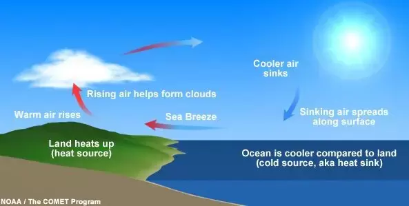
0 Comments
|
