|
If you are one who has been tracking weather across the Pacific Northwest as of late, then the terms, “atmospheric river” or “Pineapple Express” may sound familiar to you. For those who immediately think of a flowing river of water high in the atmosphere, or even Seth Rogan’s 2008 hit film, this article may be mind-altering then (in a good way of course!). In the field of meteorology, there are countless terms and phrases we use on a day to day basis that describe different types of meteorological phenomena; atmospheric rivers (ARs) being one of them. Put simply, an AR is a wide (250-620 miles), elongated (>1200 miles), and deep (≤1.8 miles) plume of condensed water vapor (moisture) that is responsible for most of the extratropical horizontal water vapor transport. Often times, this results in prolonged periods rain/snow, mainly for coastal regions. This prolonged period of precipitation can result in several inches of rain to feet of snow depending on your elevation. They are most common between December-February in the northern hemisphere. ARs usually form as byproduct of extratropical cyclones. In the US, the West Coast is most prone to these since the atmosphere flows west to east, ushering in an abundance of moisture off the neighboring Pacific Ocean. Our most recent AR event in the Pacific Northwest was called the “Pineapple Express”. The “Pineapple Express” is an AR with its moisture source originating near Hawaii, hence the name. On average, the West Coast receives nearly half its annual precipitation through just a few AR events. While ARs may be good at eradicating droughts, they also pose an increased risk of flooding, mudslides & property damage. From a forecasting perspective, it is ever evolving considering research on this phenomena began only two decades ago. Satellites, radar, offshore aircraft reconnaissance, buoys & land-based AR observatories are the main sources of information that models currently use to forecast AR location, timing & intensity. In 2019, an AR intensity scale (AR1-AR5) was developed to help communicate potential impact of these events to the public, taking the amount of water vapor and duration into consideration. As research continues to advance, a better understanding of ARs will prove beneficial to the meteorological community to allow us to forecast these events as accurately as possible to better serve the public. 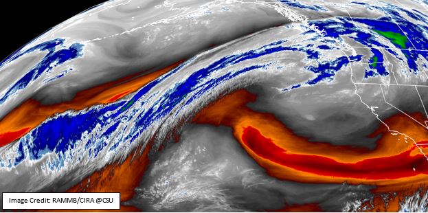 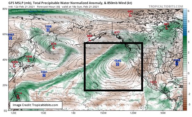
0 Comments
|
