|
There has been a lot of stir about Denver's snow potential on Tuesday, mainly because this is an uncommon occurrence for them (some say it's common but I disagree 😏). Since record keeping began back in 1882, Denver only averages ~1.0" of snow for September, so seeing models spit out really anything will raise some eyebrows. Last snowfall reported (trace) was in September 2014. Before that, the last measurable snowfall was way back in September 2000! Models have been all over the place so far, with the GFS showing as much as 20", but we can safely assume that likely won't happen. Setting the stage, a very strong cold front will move through Monday evening, resulting in a nearly 50F temperature drop between Monday afternoon and Tuesday morning! Welcome to Denver. Here are some cool stats courtesy NWS Boulder: 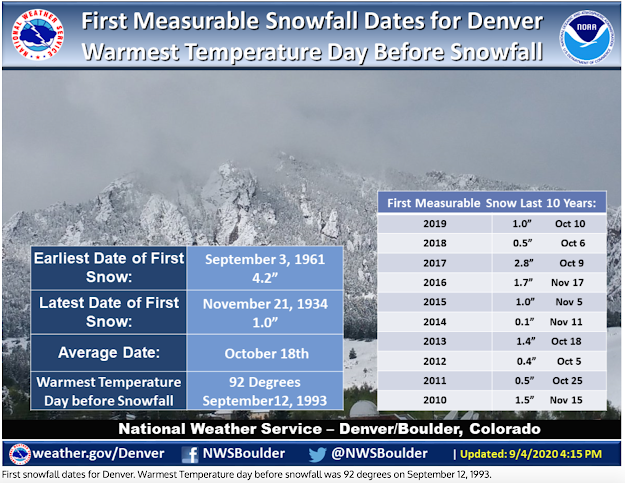 Anyways, snow (likely heavy) is currently set to begin on Tuesday morning associated with a very strong upper level trough swinging through the four-corners region. Based on 05/00Z ECMWF & 05/12Z GFS, both are in similar agreement of ~5-8" assuming a 10:1 snow to liquid ratio. QPF-wise, both models have between 0.8-1.0" liquid, and with this being a wet, heavy snow with good dynamics I think this is realistic. Remember, wet, heavy snow could result in downed tree limbs and power outages. I haven't analyzed ECMWF soundings but GFS displays excellent snow growth within its dendritic growth zone (DGZ) Tuesday morning which is between -12C and -18C (some say -17C). This is when the bulk of accumulation will happen along this front end thump (mid-morning through early afternoon). Precipitation may begin as a rain/snow mix but should quickly wet-bulb at the lower levels and flip to all snow. I think snowfall rates of 1-2"/hr is real possibility with this initial burst. This will prove to be important considering how warm surface temperatures are from the day prior (mid-upper 80's), so this burst of snow will help cool the surface faster, allowing for accumulation to occur sooner. I think the first inch or two of snow may go to waste just cooling the surface down to a temperature where accumulation can begin. In addition to what I mentioned above, a NNE-NE wind will be present, allowing an upslope component (allowing more cooling), or even a small area of low level convergence where NE winds on the Front Range collide with N winds near/along I-25. By early afternoon, I am expecting most of the snow will have fallen, with light snow possible through mid-late evening. The mountains and foothills should see the most snow, with a decreasing accumulation gradient as you move east. Although this is still a very fluid situation unfolding, as of now, I think Denver International Airport/Front Range could see anywhere between 1-3", Downtown Denver could see 3-6", and the foothills and mountains seeing between 6-12". VERIFICATION Having provided no forecast update since the original posting three days prior to this event, this forecast was outdated, but I am providing a verification analysis anyways. As you can see in the graphic below, measured totals are certainly less than what was originally forecasted. My forecast for the airport and Front Range verified well, however once we began moving west is when margin of error increased. Downtown Denver got between T-2" (I had 3-6"), and the foothills and mountains got generally between 3-9" (I had 6-12"). After doing a quick analysis of what went wrong, some dry air aloft (noticeably in the DGZ) and low levels being too warm at the start of this event is what caused totals to be lower than expected. The 12Z Denver sounding below illustrates this. At the onset of precipitation, snow was supposed to be really cranking, or at least transition from rain to snow much sooner than it did, but this dry air aloft and warm low level temperatures (surface temperatures were in the upper 80's and low 90's the day prior) didn't allow that to materialize. This resulted in a rain/snow mix for some time, thus chipping away at significant accumulation potential. Once the column began to saturate by mid to late afternoon is when snow commenced for most locations but by then it was too late for any significant totals. 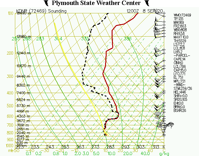 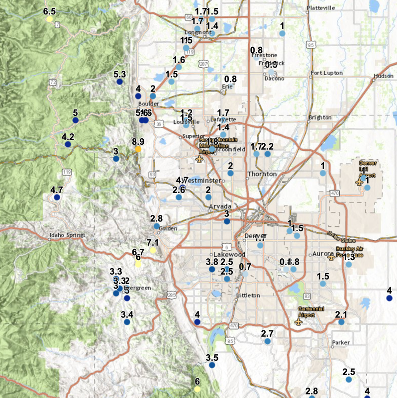
0 Comments
|
