|
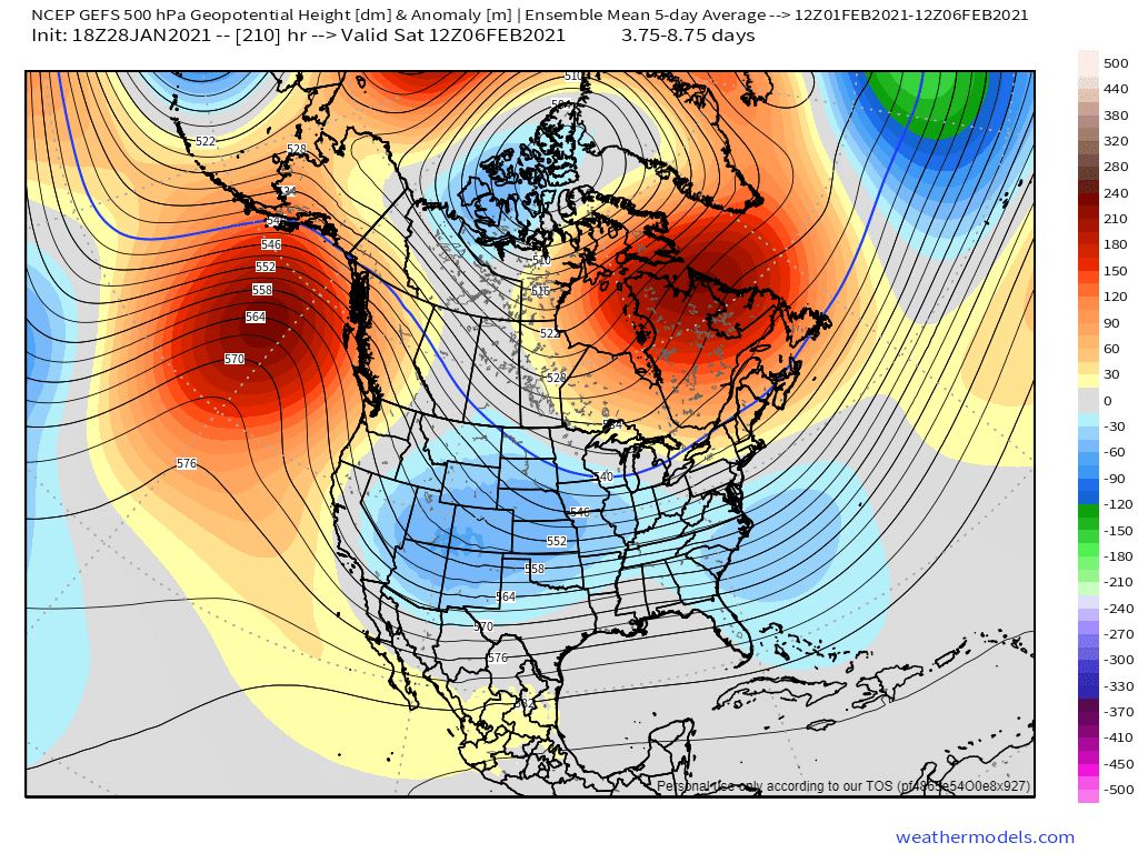
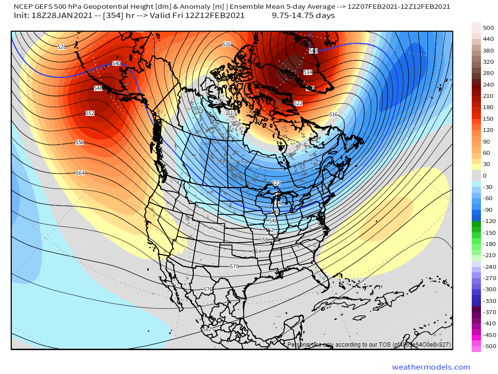
Looking ahead to the next couple of weeks, it's not out of the question to see a slight chance of wintry precipitation here in North Texas, especially next week. To start, the cold will be here, that's a given, however how "rooted" these cooler temperatures will be is not as certain. What I mean by, "rooted" is the duration and severity of cooler temperatures. For those that live in North Texas, temperatures fluctuate all the time so it's hard to get a cold airmass that lingers for more than a few days before another warm up. Looking at synoptics, we actually aren't in a bad pattern so to speak to end this month and begin next month. Alaskan ridging (-EPO) and Pacific troughing (-PNA) are in tandem (Figure 1), giving us cross polar flow and some west coast troughiness to potentially bring some unsettled weather through here. However, in my personal opinion, I don't think the west coast troughiness is far enough west, or deep enough so we are left on the "warmer" side of things with most storms passing north of us with a zonal-esque flow in the mid-levels. We could see one to maybe two slim shots of winter precipitation here with this pattern, but I'm not optimistic. During the second week of February, the pattern becomes much less favorable (Figure 2) as Alaskan ridging retracts/weakens and the west coast troughing abates. This would leave North Texas in a potentially dull pattern from a weather standpoint although it could still be slightly colder than normal.
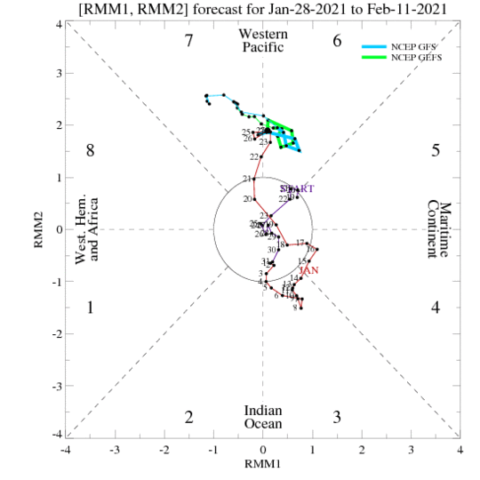
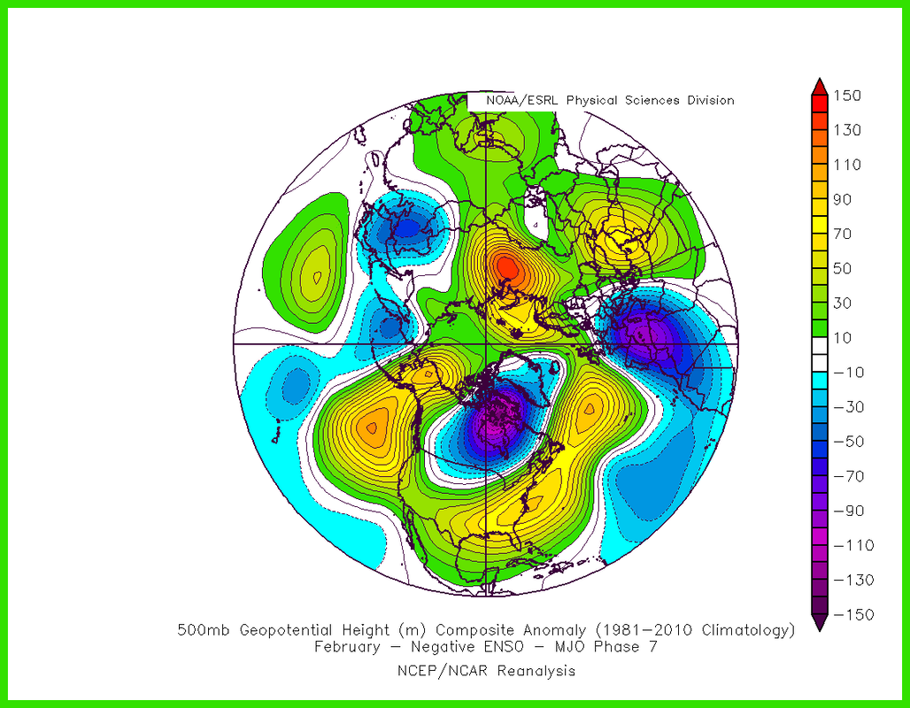
Looking beyond two weeks things get a little trickier, but they don't look great when referencing MJO composites. The MJO is slowly heading towards Phase 7 by early February (Figure 3). Figure 4 is the climatological composite of a February, Phase 7 MJO during La Nina. If the -NAO were to trend positive mid-month (which it may), we could end up in a pattern similar to this, with ridging over much of the central and eastern US. This would equate to warmer than normal temperatures for the latter half of the month, making any shot at wintry precipitation in North Texas very difficult. It's still early, but initial signals do not look promising.
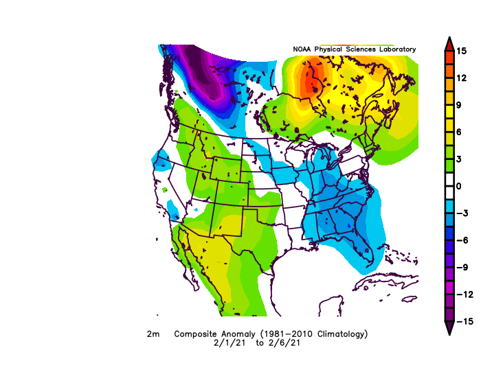
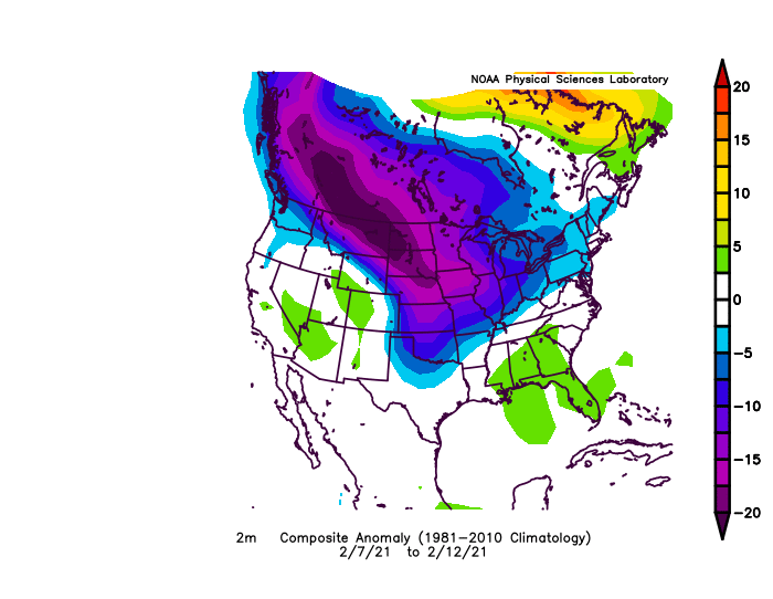
VERIFICATION Despite how eventful February was, my first half outlook verified pretty well. North TX finished warmer than normal February 1-6 (Figure 5), and cooler than normal February 7-12 (Figure 6). As we all know, the second half of February was record shattering, and nowhere near the composites, with historic cold affecting most folks living in the central US. Figure 7 shows the temperature anomalies for February 13-28. Recent analysis suggests the SSW in January helped trigger a SPV stretching event in February that opened the floodgates for the Arctic air intrusion.
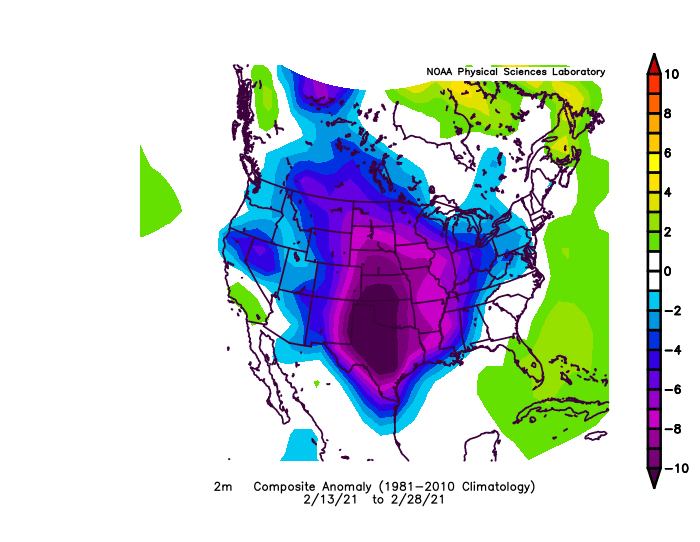 Figure 7
0 Comments
Earlier this month, stratospheric warming began. This has a large influence on meteorology when it comes to medium to long range forecasting. Stratospheric warming occurs when atmospheric waves from the troposphere move into the stratosphere. These planetary waves are forced by the large-scale mountain systems and land-sea contrasts. The wind structure of the stratosphere serves as a filter, allowing only the planetary waves to enter the stratosphere. As these waves move upward into the stratosphere they do two things: 1. They will often push the polar vortex (PV) away from the North Pole. This brings warmer, midlatitude air northward, and cooler, arctic air southward. A downward motion field also causes the poles to warm further. The mixing of these air masses enhances storminess/snow in mid-latitudes. Usually a -NAO develops with this type of event. 2. Warm the stratosphere. This is caused when the stratospheric PV breaks down. This breakdown may not propagate into the troposphere. A good way to prog this is to look at temperature and a weakening/reversal of stratospheric winds (going from west to east). This is all caused by the Rossby (planetary) waves as stated before. As these waves enter the stratosphere, it causes the mean flow to decelerate, weakening the Polar Night Jet (causing the PV to weaken or split). With the weakening of the PNJ, its winds then begin to converge towards the center and descend, resulting in warming due to compression. Once these winds shift east, all planetary waves can no longer move up, so this remnant energy moves down through the stratospheric column, disrupting the vertically stacked PV. Once winds shift east, ridging patterns are usually evident in the mid-upper latitudes. In propagating events, the disruption of the tropospheric PV continues, which allows cold air to be displaced from high latitudes and spill south. This is why stratospheric warming is associated with cold outbreaks, which generally last for weeks. Stratospheric warming events have a tendency to occur earlier in the winter if we have a -QBO and low solar radiation. Now about the Polar Vortex... Air inside the Polar Vortex is usually very cold, and low in ozone content. Strong Polar Vortex: This is the more common state for the PV. When it it strong, a strong low pressure exists over the poles, which confines all the colder air. Therefore, it is often mild across the Eastern US, Europe and East Asia. When the PV is strong, the AO/NAO are said to be in their positive state. Weak Polar Vortex: When the PV weakens, the air flow is weaker which allows it to meander more. This is what allows colder air to spill into lower latitudes and warmer air to travel north. This is favorable to storm development due to the potential mixing of air masses. Eastern US, Europe, and East Asia are often colder during a weak PV. The AO/NAO are also said to be in their negative state during this time. For the purpose of illustrating this as best as possible, the images below are from 2013 (from my other weather blog) representing the warming aloft (1st picture), and the wind reversal aloft (2nd picture). 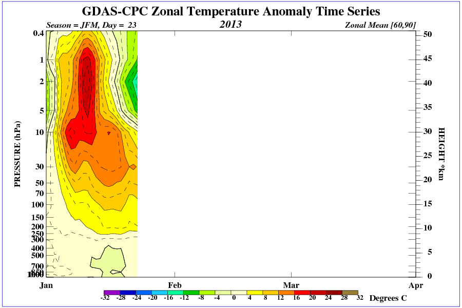 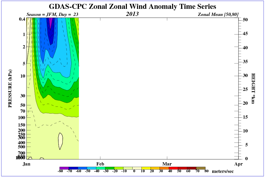 The following two images show the wind reversal as well. Focus on 60N-80N latitude and notice the reversal. This is textbook top-down propagation: 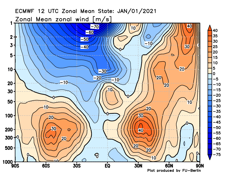 Decided to take a closer look at ENSO's influence on DFW snowfall. El Nino increases snow chances for DFW, while La Nina & ENSO Neutral phases result in decreased chances for snowfall. DFW's best (snowiest) winters occurred when El Nino was weak or moderate. DFW's worst (least snowy) winters occurred when La Nina was moderate or strong. The jet stream is displaced north & more variable during La Nina, so we will get occasional cold snaps creating windows of opportunity for wintry precip but it is typically difficult to get the cold and moisture simultaneously. Dataset in the graph below is from 1950-2020. The section called, "Mixed Phase of La Nina" denotes a winter season where La Nina went from strong to weak. 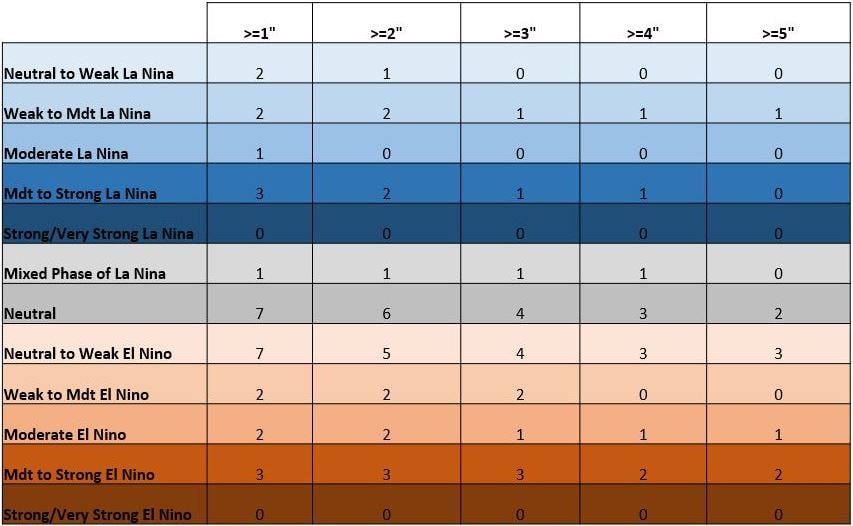 |