|
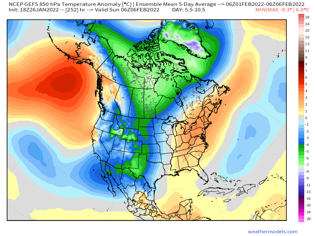
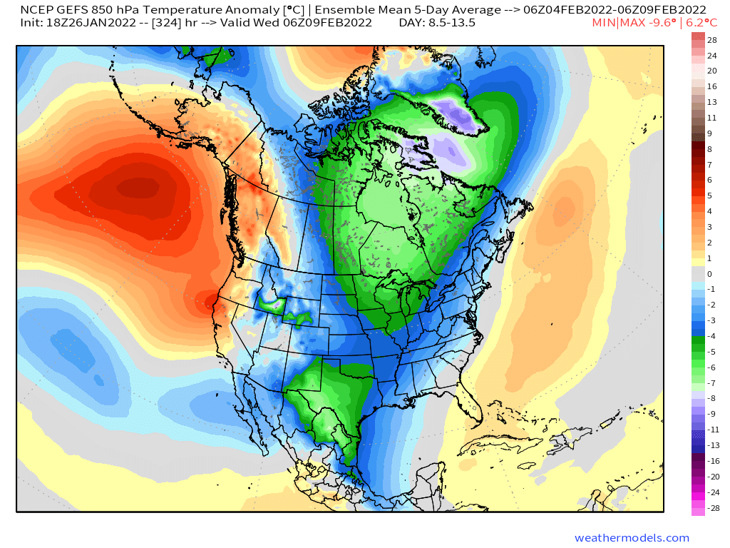
As we approach the end of January, you may be surprised to read that DFW's current average temperature is nearly normal for the month. Now, how we got here was like riding on a roller coaster, beginning with a deep freeze early this year with temperatures in the teens followed by a very warm stretch mid-month when highs nearly hit 80F! Looking ahead as we flip the calendar to February, it's safe to say a pattern change is on the way that will be accompanied with cooler temperatures and what I consider a favorable synoptic setup (i.e. storm track) for winter weather. Taking a look at this first five days of February (Figure 1), there are a few key features to focus on. Starting up in the Gulf of Alaska, there is an area of robust ridging (reds) that will be the source of the cold air that is sent south. If you follow the isohypses (lines of constant height), it's easy to track how the cold air will get here and spread east over time (Figures 2 & 3). Across the SW US, there is an area of troughing (blues), which spills into the Central Plains as well. Notice the trough axis is centered over the SW US. This is a good look because any piece of energy (shortwave) that originates out of British Columbia or the Pacific NW will have time to amplify/phase as it moves south before it ejects out of the SW US towards Texas. In real simple terms, it gives any potential shortwave time to "fuel up" before it makes its trek east. The deeper this trough, the easier it is for cold air to pool up to support any chance of snow/sleet in north-central Texas. Jumping east, there are an area of higher heights (oranges) downstream of this trough. This area can serve as a "block", which would slow down the eastward progression of any weather system that moves through Texas, although to be perfectly honest, I don't expect this to play a huge role at the moment, but certainly something to monitor incase those higher heights (ridging) shifts west.  Figure 1
While looking ahead on the deterministic models, there is a potential risk of winter weather here in north-central Texas thanks to the aforementioned pattern however it is still too early to say with confidence if snow will be the end result. For that reason, I am holding off on posting any images since confidence is too low at the moment, but I am keeping an eye on it because the synoptic pattern is a lock at least. Looking beyond the first week in February, current guidance suggests that that troughing over the SW US weakens, leaving us with more of a zonal flow resulting in a return to more seasonable/slightly above normal temperatures along with a reduced storm/snow risk.
0 Comments
Gravity waves have been a frequent feature on radar imagery during Winter Storm Izzy which begs the question, what causes these?  Gravity waves develop when air is forced to rise in a stable environment. In this case, the cold air damming setup has resulted in a low level temperature inversion as shown in the soundings from FFC & GSO (Figure 1). 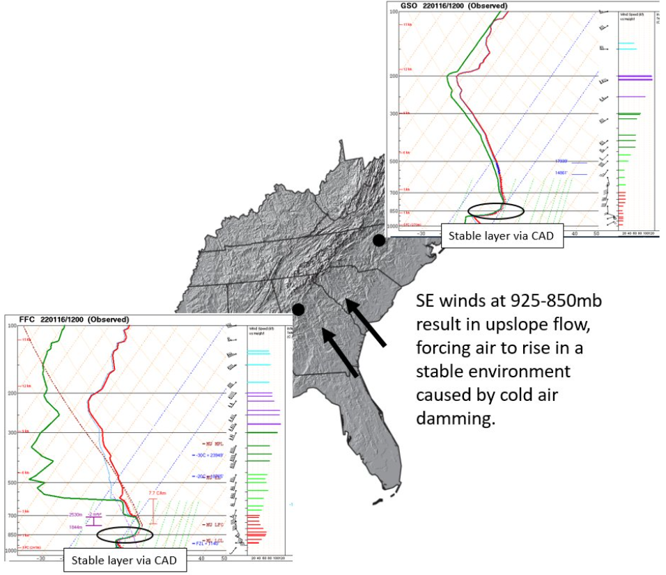 Figure 1 Early this morning, E-SE flow was prevalent across much of GA, NC & SC, resulting in upslope flow (Figures 2 & 3). This forces air to rise into the stable air mass until it becomes cooler than its surroundings, causing it to sink As it sinks, the air parcel becomes warmer than its surroundings and is forced back up. This sinuous rising/sinking motion continues which is what causes these waves.
|