|
Frequently, people use the term, "polar vortex", but what few may know is that there are actually two kinds (tropospheric & stratospheric). So what's the difference? The tropospheric polar vortex (TPV) is larger and lasts year round. The stratospheric polar vortex (SPV) on the other hand only exists between fall and early-mid spring before it breaks down. Thus, these two features are not directly correlated, but may influence each other at times. Below is a schematic from Waugh et.al (2016) that shows the disparity between the two. Notice that at around 100 hPa (tropopause), there is a pretty clear cutoff between the two types of vortices. During the boreal winter, you will also notice that both vortices are stronger than during the summertime. Come spring, sunlight returns to the polar regions and high latitude westerly winds weaken and slow down before becoming easterlies by summertime. 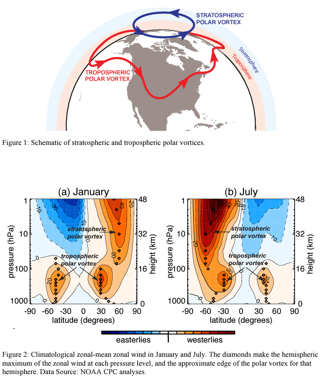 The SPV is generally strongest around 60 N/S and appears each winter as a result of large-scale temperature gradients between the mid-latitudes and the pole. The TPV is usually strongest around 45-50N/S, and usually has one or two centers, oftentimes more on a day to day basis.
These two types of vortices also impact our surface weather in different ways. The TPV can be the primary source of cold air when it is displaced from the poles. The SPV on the other hand is a bit more complicated. In order to see the impacts of the SPV, it needs to become unstable. It becomes unstable via a phenomenon known as Sudden Stratospheric Warming which you can read about here. Hopefully this brief overview provides more clarity on the main differences between these two vortices and assists you in better understanding how they impact our surface weather.
0 Comments
Leave a Reply. |
