|
With snow officially underway across much of DFW Metroplex, DFW will likely report measurable snow for the first time since January 11, 2020 (nearly one year to the day). Whether DFW breaks its near 6 year drought of 1" or more remains to be seen but I remain optimistic (Update: they did not - only a trace was reported. Low-level dry air (~850mb) and surface temperatures being too warm made it difficult for accumulating snow). The last time DFW recorded 1" or more of snow was on March 5, 2015. The beginning of this winter season has been an odd one to start, especially being under the influence of La Nina, which is currently moderate. Historically, with a La Nina in place, DFW generally experiences warmer and drier winters due to a weaker jet stream. Although we have been slightly warmer than normal so far, we have been slightly wetter than normal. We are still very early into the winter season so I wouldn't put much stock into these right now, however if you have been following the weather, West Texas has been getting hit with record snowfall attributed to an anomalous upper air pattern consisting of an intricate interaction of the +WPO, +EPO, +PNA & -NAO to simply put it. While most of that hasn't translated east into the Metroplex (until today), I believe the medium to long range outlook looks more promising for an increased snow risk here in DFW. Beginning at the end of this week is when the synoptic pattern begins to change a bit, allowing a more consistent surge of cooler air and troughiness (storminess) to the Southern Plains. To break it down a little, the NAO will remain negative through at least the end of the month, however there is some indication by the models that the EPO will begin to go negative, or at least weaken, which allows cold air that pools up in the higher latitudes to spill south, giving us the antecedent airmass we need for wintry precipitation. This cold air that pools up can also be "fueled" by what has been a consistent +WPO which provides even more polar (and even arctic) air from higher latitudes, however becomes less of a factor the second half of this month. Lastly, the PNA is forecast to tank at the end of this week which provides the troughiness (blue shading) we need for storms here in North Texas. The image below is a good illustration of what the "average" pattern will look like in the mid-levels of the atmosphere beginning mid-month: 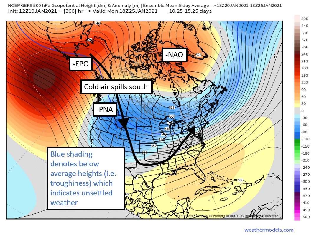 While this setup increases our chances of seeing wintry precip here, we may end up with just cooler than normal to normal temperatures for this time of year. Same applies to precipitation. Depending on the exact setup of this synoptic pattern, some storms may miss us to the north, some may miss us to the east, OR, if a storm does hit us, it needs to be cold enough to generate any wintry precipitation so a lot still needs to go right. All in all, while it is naturally difficult to get winter precipitation in DFW, I think our chances are increased with this expected pattern shift mid-month.
0 Comments
|
