|
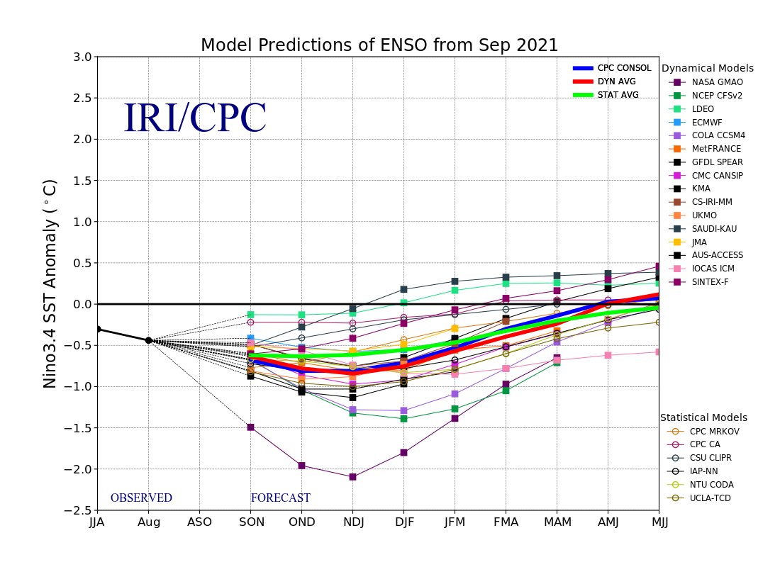
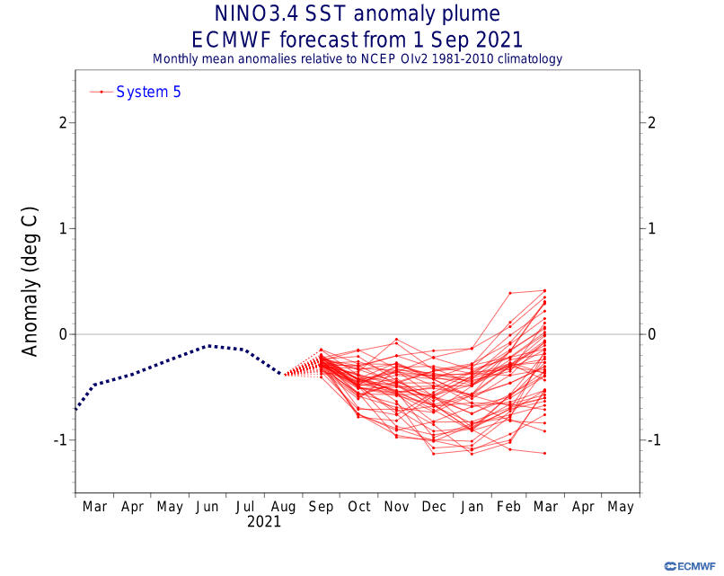
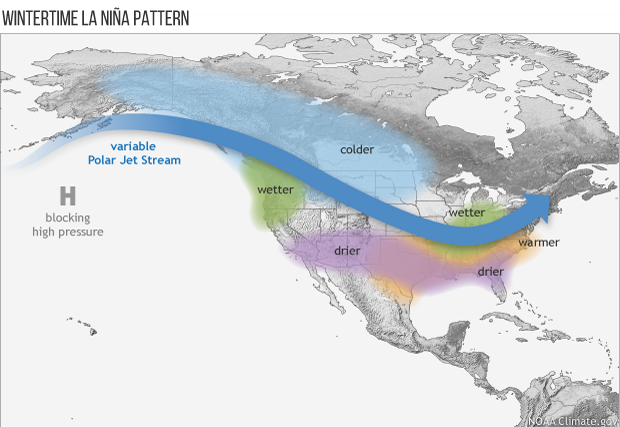
Could a winter as harsh as 2020-2021 make a grand return in 2021-2022? Likely not, but another eventful winter may be in the cards for 2021-2022. Let's start with the main drivers that could influence our wintertime pattern here: ENSO The base state of Nino 3.4 is currently neutral, however model guidance suggests were are very close to re-entering La Nina. Assuming we re-enter La Nina within the next month or so, SST for the Nino 3.4 region are expected to remain cool enough to keep it within La Nina thresholds through at least the first half of winter. Current forecast for this upcoming winter calls for a weak to moderate La Nina (SST>=-1.4<=-0.5) . Figures 1-3 below show the varying forecasts, all of which are in agreement for the return of a La Nina winter. What does La Nina mean for us in north TX? Well, generally speaking, during La Nina, the SST gradient between the central and north Pacific is weaker, resulting in a wavier and more variable jet stream. While DFW is generally warmer and drier during wintertime La Ninas, there are usually brief periods where the Polar Jet Stream gets displaced far enough south to allow for some anomalously cold temperatures to make it into north TX and given the right situation, wintry precipitation as well.
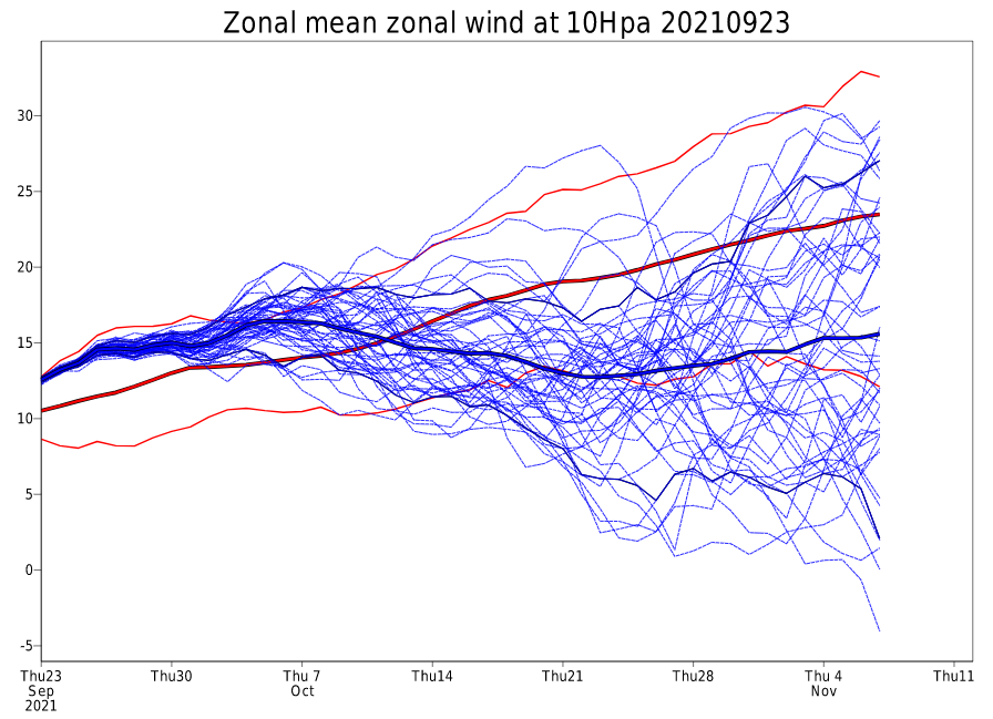
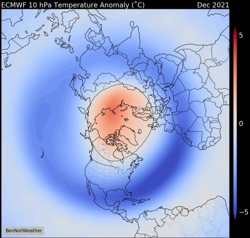
Stratosphere Some of you may be thinking, "what does the stratosphere have to do with wintertime here?". Believe it or not, it can have a large influence on how cold it actually gets here. Way up in the stratosphere, it is normally very cold, but there are times when it "warms up" relatively speaking. How does it warm up, and what happens when it does? I wrote a blog earlier this year explaining how that can happen: Click Here Model guidance has been quick to cite a weak stratospheric polar vortex (SPV) with a potential warming episode as early as December, which is not a common occurrence. Early signs can be illustrated in the following 10 hPa zonal wind speed anomaly forecast (Figure 5). Wind speeds are forecasted to be in the lowest 10th percentile at the end of October. While this doesn't equate to warming, it is trending in the right direction. Figure 6 shows what the ECMWF is forecasting for temperature anomalies at 10 hPa. Notice the red blob over the North Pole. That is indicative of SSW.
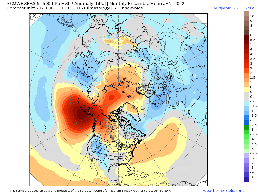
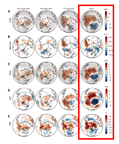
Quasi-Biennial Oscillation (QBO) For those that don't know what the QBO is, here is an excellent link explaining it: Click Here. The QBO is currently in an easterly phase and descending. These conditions are expected to remain through this upcoming winter. See Figure 7. When the QBO is in an easterly phase, it correlates with an increased chance of SSWs, which could result in a weaker jet stream if the stratospheric polar vortex disruption works its way down into the troposphere. Another thing to take note of is when the QBO is easterly and concurrent with La Nina or ENSO neutral, chances of high latitude blocking are increased which is known to deflect cold into the lower latitudes. 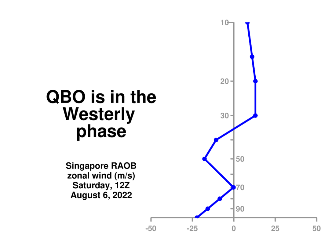 Figure 7 Okay so let's get to the good stuff...what does all this confusing scientific talk mean for us here in north TX? When taking everything into consideration, it suggests some anomalous cold snaps are possible along with an increased chance of wintry precipitation. How sure am I of this? In weather, nothing is ever certain but history lends some merit to this idea: There have been five Decembers on record where a SSW event occurred during an ENSO neutral or La Nina phase. Those years are 2003, 2001, 2000, 1998 & 1960. Of those five Decembers, four of them resulted in accumulating snow >=1" at some point that winter. Those years were: 2003: 2.6" 2001: 3.8" 2000: 1.5" 1960: 6.4" During those winters, surface temperatures were also colder than normal, as expected (Figure 8). 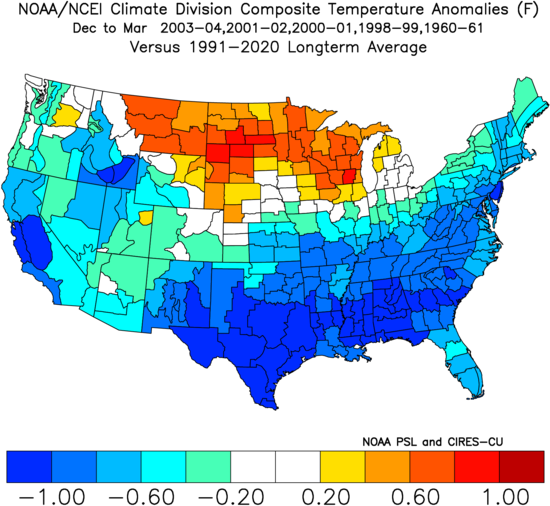 Other December SSWs that did not fall in an ENSO neutral or La Nina year occurred in 2018, 1997, 1987 & 1968. During those years, there was no significant snowfall (>=1") during those winters other than the the winter of 1987-1988 where 3.5" fell. What is also worth consideration is even if we take an early SSW event out of the picture, SSW episodes occurring concurrently with La Nina correlates to increased chances for snowfall. Best example was this past winter, where a January SSW event occurred and in February north TX reported record cold and snow. However, I do want to point out that the January SSW event may not have been the underlying reason for February's historical weather. Upper air analysis indicates that an event known as a SPV stretching event may have been the driving force for the record setting cold in February, however the January SSW may have triggered that. The winter of 1984-1985 also had a SSW event on January 1st during a La Nina which resulted in record cold and snowfall then as well. Taking things even one step further, the current SEAS5 forecast for January 2022 (Figure 9) aligns well with a recently studied synoptic pattern (Figure 10) that is now thought to enhance the chance of extreme cold episodes in North America via SPV stretching events. It involves ridging over the Urals and North Pacific in conjunction with increased autumnal Siberian snowfall (E Asia troughing), which favors SPV stretching events. There is generally ~1-2 month lag between the aforementioned Arctic forcing and the cold outbreak itself which could provide significant forecasting lead time, resulting in better preparation. SPV stretching events are increasing, implying potentially more frequent extreme cold snaps.
In summary, there are plenty of early indicators that another eventful winter may be in store for north TX, especially if a SSW event occurs. Even if one doesn't, having La Nina present should provide a handful of opportunities to see brief periods of anomalous cold make its way into north TX. Figure 12 below shows the correlation of ENSO phase and reported snowfall in DFW. The key takeaway from this chart is that most of the snowfall events during La Nina occur when La Nina is of weak or moderate intensity, which is the forecasted strength of La Nina this upcoming winter. 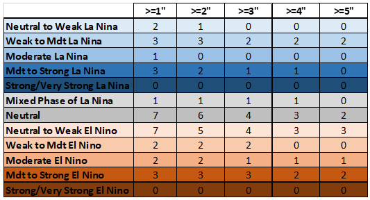 Figure 12 Did You Know...
DFW has reported >=1" of snow during a La Nina winter 43% of the time. DFW has reported >=1" of snow during an El Nino winter 52% of the time. DFW has reported >=1" of snow during a Neutral winter 33% of the time.
0 Comments
Leave a Reply. |