July Outlook: New England
Thursday, June 30, 2022
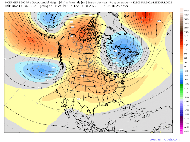
With the month of June concluding, it has been a seasonable month in regards to temperatures, with drought conditions still ongoing. July's outlook is shaping up to be on the warmer side, with persistent ridging across the Lower 48. Unfortunately, this means that drought conditions will likely continue/worsen as the month progresses. The lack of soil moisture will also pave way for temperatures to be above normal with less to evaporate. Below is a snapshot of the GEFS 500mb 5-day height anomalies for what the general pattern will look like for most of the month. GEFS, along with EPS nudge the ridge west while flattening it towards the latter half of July but it shouldn't have much, if any, impact on temperatures or precipitation for that matter. The mean low-mid level flow for the month will be mainly out of the west which translates to warmer than normal temperatures for Southern New England. Of note are the lower heights over Northern New England which is a result of a displaced omega block over Canada. While this should deliver some "cooler" temperatures to that region during the first half of July, I'd be hard pressed to say that it'll have much impact on the monthly average overall, which I am still expecting to be above normal based upon my prediction of the middle-latter half of July being warm enough to offset it.
With the month of June concluding, it has been a seasonable month in regards to temperatures, with drought conditions still ongoing. July's outlook is shaping up to be on the warmer side, with persistent ridging across the Lower 48. Unfortunately, this means that drought conditions will likely continue/worsen as the month progresses. The lack of soil moisture will also pave way for temperatures to be above normal with less to evaporate. Below is a snapshot of the GEFS 500mb 5-day height anomalies for what the general pattern will look like for most of the month. GEFS, along with EPS nudge the ridge west while flattening it towards the latter half of July but it shouldn't have much, if any, impact on temperatures or precipitation for that matter. The mean low-mid level flow for the month will be mainly out of the west which translates to warmer than normal temperatures for Southern New England. Of note are the lower heights over Northern New England which is a result of a displaced omega block over Canada. While this should deliver some "cooler" temperatures to that region during the first half of July, I'd be hard pressed to say that it'll have much impact on the monthly average overall, which I am still expecting to be above normal based upon my prediction of the middle-latter half of July being warm enough to offset it.
VERIFICATION
New England, especially MA, CT & RI finished well above normal for the month thanks to robust ridging over the Central Plains and Southeast US. This type of synoptic setup advected that warm air towards New England via southwest/southerly flow. Figure 1 shows the 500mb gph anomalies for the month illustrating strong ridging over most of the Lower 48. The highlight of the month was the 7-day heat wave from the 19th-25th which included one triple-digit day. Boston will finish ~3-4F above normal thanks largely in part to this heat wave.
New England, especially MA, CT & RI finished well above normal for the month thanks to robust ridging over the Central Plains and Southeast US. This type of synoptic setup advected that warm air towards New England via southwest/southerly flow. Figure 1 shows the 500mb gph anomalies for the month illustrating strong ridging over most of the Lower 48. The highlight of the month was the 7-day heat wave from the 19th-25th which included one triple-digit day. Boston will finish ~3-4F above normal thanks largely in part to this heat wave.

|

|
June Outlook: New England
Thursday, June 2, 2022
June could potentially be a month of two types of patterns for New England: cooler/rainy & warmer/sunny. Let's break down each scenario by looking at teleconnections.
With a -NAO (ridging over Greenland)/+PNA setup (ridging over W US), this would normally be a snow weenie's dream setup had it been winter, however when talking late spring, cooler/more seasonable temperatures and above normal cloudiness/rainfall are favored.

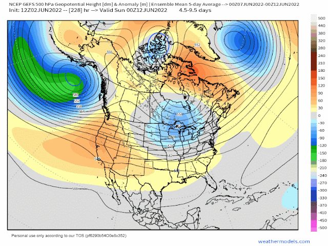
In the figures above, both the GEFS & EPS show blocking (ridging) in the vicinity of Greenland, with below normal 500mb heights across the Midwest and much of the eastern US. A setup like this would favor cooler and wetter than normal conditions through at least the next week. Though the sound of rain doesn't sound appealing, the silver lining is that it would help alleviate current drought conditions across far eastern New England.
Beyond the next 7-10 days forecast confidence drops, however the GEFS (below) has the Azores high build far enough west to weaken the -NAO and result in more of a ridging pattern for the Eastern US. This would favor drier and above normal temperatures for the second half of the month. The EPS strengthens the Azores high but does not build it west like the GEFS does but is worth watching to see if it follows suit.
Beyond the next 7-10 days forecast confidence drops, however the GEFS (below) has the Azores high build far enough west to weaken the -NAO and result in more of a ridging pattern for the Eastern US. This would favor drier and above normal temperatures for the second half of the month. The EPS strengthens the Azores high but does not build it west like the GEFS does but is worth watching to see if it follows suit.
VERIFICATION
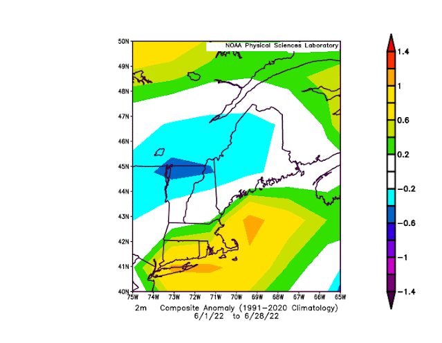
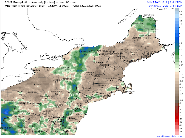
New England's temperature as a whole finished seasonable when taking all of the anomalies into consideration, with Northern New England finishing cooler than normal and Southern New England finishing warmer than normal. Recorded temperature anomalies were actually flipped from what was forecast, with warmer than normal conditions being felt the first half of the month as lower mid-level heights remained further west than modeled. Cooler than normal temperatures were felt the second half of the month as lower mid-level heights were recorded over SNE. A lot of this was contributed to a record setting mid-level trough that swung through New England which brought anomalously cooler temperatures to the region for several days. This was not picked up by ensemble guidance when the forecast was made, nor would I expect it to. Drought conditions continued for New England, with some locations ~2" below normal for the month.
New England's temperature as a whole finished seasonable when taking all of the anomalies into consideration, with Northern New England finishing cooler than normal and Southern New England finishing warmer than normal. Recorded temperature anomalies were actually flipped from what was forecast, with warmer than normal conditions being felt the first half of the month as lower mid-level heights remained further west than modeled. Cooler than normal temperatures were felt the second half of the month as lower mid-level heights were recorded over SNE. A lot of this was contributed to a record setting mid-level trough that swung through New England which brought anomalously cooler temperatures to the region for several days. This was not picked up by ensemble guidance when the forecast was made, nor would I expect it to. Drought conditions continued for New England, with some locations ~2" below normal for the month.